| Project
|
|
|
 |
How to order VPS.system?
The VPS software is available for each country if the necessity
can be declared by a formal letter to
Ministry of Energy, Agriculture, the Environment, Nature and Digitalization
Department for Water Management, Ocean and Coastal Protection
Mr. Claus Böttcher
Mercatorstraße 3
24106 Kiel
Phone +49 431 988 3460
E-Mail claus.boettcher@melund.landsh.de
We obviously recommend to start the procedure with some
training to understand the system and the data processing in
detail.
The delivery will include software only, without any data,
because these German data are protected - and in any case would
not be applicable abroad.
|
|
|
Starting Phase 1997-2000
The scope of the whole project contained:
- the contentual conception of the provision planning,
- the creation of technical possibilities for its implementation and
- the elicitation of respective usage along the ca. 3,600 km of the German North and Baltic Sea coasts:
- Topographical master chart of coast regions with a coast kilometerage in a 0,5 km-grid
- Electronic sea chart (Electronic Navigational Chart ENC)
- Additional topographical information such as shore type (norm profile), accessibility, industrial buildings, flood protection buildings, etc.
- Symbolic display and interpretive data regarding protection zones, tourist facilities, storage for locations for response equipment, etc.
- Technical data for existing response equipment
- Address- and phone data of relevant corporations and individuals
- Alarm plans for coastal states and emergency prevention cases as well as for complex pollution accidents
- Electronic response manual including combating proposals for defined shore types
- Photos of the entire coast line
|
|
|
Project implementation
After the decision of the project initiator for the creation
of a data processing system, a low-cost solution was compiled
with the guidance of a project management team, created under
the auspices of the Free and Hanseatic City of Hamburg and with
assistance from a project accompanying commission (Working team
of one person each from the coastal states and the Central
Command for Maritime Emergencies).
The first working step consisted of:
• the development of a professional detailed concept,
• the conceptual planning of the data processing system in a
detailed concept,
• the development of the software,
• the data elicitation for two pilot areas. |
One measure for the implementation of a short-duration (and with
that low-cost) project was an isochronic development of the IT-system
and the data collection for two pilot areas that contained
different norm profiles. To implement that within the IT-detail
concept, software from a data collecting module was provided.
The data collection module was a tool for several contractors
that collected and edited data of two pilot projects ("Wurster
Küste", ca. 30 km of North Sea coast and "Klützer Winkel", ca.
12 km of Baltic Sea coast), that are relevant for pollution
response.
With the data collection module, the data formats planned in the
IT-detail concept were given. Through this it was secured that
only data were collected that could be managed from the IT-system
without restrictions.
Simultaneously, there was a permanent coordination between the
developer of the IT-system and the data-collection engineering
offices. That was important for making adjustments to the IT-system
or to the data collecting module.
Finally, after the data transfer, functional tests were made in
the coastal states concerned and a contentual and structural
control of the collected data was done.
The development of the topographic Basic Maps
was necessary before the data collection, to exactly define and
specify the situation in the whole exploration area. A different
interpretation, for example of the coast section borders, by the
different contractors was excluded by that.
The basis of the basic maps are ATKIS-data from the land
surveying offices, which supplemented integrated coast features
such as dike kilometerage. An intensive structural and
contentual control by the project initiator after the
presentation of the depiction of the both pilot projects led to
a revision and the commision of extensive data collection along
the coasts.
During the 2 ½ years of the project duration, from 1997 to 2000,
40 orders were placed for a total 1,8 Mio EUR.
|
|
|
|
Updating of data
Every IT-application will be only accepted if it
is user-friendly, is an essential help, and can be maintained
with the smallest cost effort.
Firstly, the local user of VPS knows how to update data and
these data will be recognized by the users of the Central
Command for Maritime Emergencies. The new datasets are provided to the users as a
download from the VPS-website or by the update service of this software.
The Federal Maritime and Hydrographic Agency is the data supplier for many marine geodata and provides the electronic nautical chart on an annual basis as well as data on offshore structures every six months.
The offline-capable versions of the topographic base maps stored in the system are based on data from the Federal Agency for Cartography and Geodesy and on OpenStreetmap data. This data is updated annually.
The offline-capable orthophotos (aerial photographs) contained in the system are updated every three years.
In addition to the maps stored in the system, a number of other maps and aerial photo atlases are available online, which are up-to-date and maintenance-free. An external service provider is commissioned with the ongoing detailed work of data maintenance and data collection. This approach has proved successful since VPS.system went into regular operation in 2000.
In the years from 2014 to 2022, all coastal data from the initial collection in 2000 was completely checked, corrected if necessary and supplemented so that it can continue to be used as a solid database. This update was resumed in 2024 and will be continued in subsequent years.
|
|
|
|
Further development of the system
 VPS.system
has been developed in many respects since the launch in the
year 2000. This development is primarily a permanent
modernisation of the software, which is now available as the
version VPS.system 2009. VPS.system
has been developed in many respects since the launch in the
year 2000. This development is primarily a permanent
modernisation of the software, which is now available as the
version VPS.system 2009.
 The working group Contingency Planning, including the the
Central Command for Maritime Emergencies (CCME) since it´s
formation in 2002, made functional modification and
amendment proposals that were implemented over the years,
and some subsequently revised when the proposals didn't
prove effective. The working group Contingency Planning, including the the
Central Command for Maritime Emergencies (CCME) since it´s
formation in 2002, made functional modification and
amendment proposals that were implemented over the years,
and some subsequently revised when the proposals didn't
prove effective.
Resulting from the request of the CCME, some operative
programme elements (such as routine logbook or progress
tracking) were necessary. Asa result, the rather static
programme became a more operational progress and accident
management tool.
|
|
|
 In
the year 2002, VPS came into international focus when the
German provision methodology was transfered to the needs of
St. Petersburg in 2002. An independent Software CPS, based
on VPS, was created. In
the year 2002, VPS came into international focus when the
German provision methodology was transfered to the needs of
St. Petersburg in 2002. An independent Software CPS, based
on VPS, was created.
A similar project was initiated in Malta in the year 2006
and the result, a VPS.system-version named MERMS+10, became
operational in May 2007 at the Malta Maritime Authority.
Furthermore, the usage of VPS.system was tested in Denmark
through a pilot project.
For this purpose, a VPS-dataset was build for the Island of
Bornholm and it was used with VPS.system 2007.
In February of 2008, a version of VPS.system for the
Estonian Rescue Board of the Environmental Minister was
created and installed in Tallinn. The name of this software
is 'Estonian Emergency Situation Information System (EESIS)'
and not only functions in the matter of maritime contingency
planning, but in the wider field of disaster management.
The assumptions for international programme such as
multilingualism, flexible saving of programme settings, and
the use of an international common UTM-coordinate system
were created with the version VPS.system 2007, and offers a
basis with which the project can be continued successfully
after more than 10 years in operation.
Additionally the system contains components that can be used
for the preparation, performance, and analysis of exercises
and components.
Further components were made for the operative work of the
Maritime Emergency Reporting and Assessment Centre.
Because all these components are bundled and linked to each
other, VPS.system is a comfortable program system, which
covers many fields of duties within martime accident
provision and the accident management.
|
|
|
| The VPS-System deals with several data types:
|
 |
Alphanumerical data describe the wide spectrum
of coastal zone characteristics, response equipment, protected
areas, alarm plans, etc., and are stored in a database. Access
to this data is possible through an easy-to-use front end
database. |
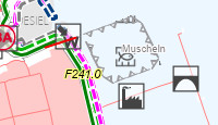 |
Geo-data are the basic maps, the
information of the Electronic Nautical Chart, as well as the geo
data that are collected in a project-specific manner, and the
data containing the relevant information for response measures.
The geo-data are mostly stored as files in a file system and made
accessible to the user by means of a GIS-module embedded in the
VPS.system front end. |
 |
Text data forms the basis of the Combating Manual, the Device Manual and an extensive library of other documents. The text data is stored together with associated graphics and photos as electronic documents in the usual formats. |
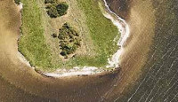 |
Photo/image data
A large amount of image data is created during the comprehensive photography of the coast, which is documented airborn from the sea with overlapping photos. The image data is saved as compressed files in the programme and as full photos on the VPS.server in the cloud. They each have a master data record in the database. They are displayed in the appropriate context in the entire VPS.system. |
| |
|