|
Sensitivity Mapping North Sea: Partners and Objectives
|
|
North Sea Sensitivity Mapping: Partners and Objectives
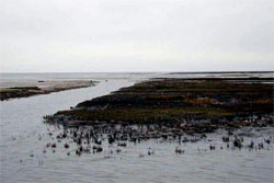
The Wadden Sea is an area of tidal flats and salt marshes
located along the North Sea coasts of Denmark, Germany and the
Netherlands. It has enormous value as a cleansing site for North
Sea water, as a nursery for juvenile fish, and as a feeding
ground for many bird species. Due to the proximity of important
shipping routes and harbours, this region would be especially
threatened by and vulnerable to oil spills.
Thus, for oil spill response and prevention measures, a
sensitivity study of the entire intertidal area was sorely
needed in order to assess and minimize the potential ecological
and economical impacts.
|

 |
Based on comprehensive field surveys, and in close cooperation
with the Central Command for Maritime Emergencies, an automated
expert-model for the German portion of the Wadden Sea was
developed at the Institute for Coastal Research (GKSS-Research
Centre). As an operational model, it will serve as an important
instrument for decision-making processes, preventative measures
and the further design of oil spill response strategies .
Sheltered tidal flats, salt marshes, and adjacent estuaries
belong to the types of coast which are most sensitive to oil
pollution. Since it is not possible to protect the entire German
North Sea coast at all levels equally, oil spill contingency
planning requires a more detailed classification.
Texts and some illustrations on these pages relevant to sensitivity mapping of the North Sea coasts were taken from the final report of the GKSS for this research topic.
|
 |
|
|
|
|